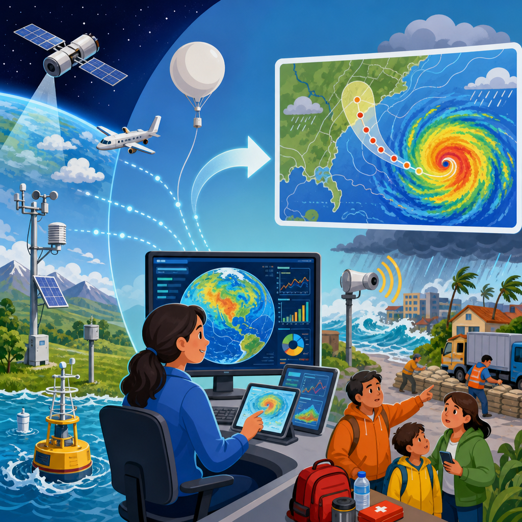
Climate data improves disaster forecasting by turning weather observations, long-term records, satellite measurements, and model outputs into earlier warnings, sharper risk maps, and better preparedness decisions. In disaster preparedness, climate data means more than daily forecasts. It includes historical temperature and rainfall trends, sea surface temperatures, soil moisture, snowpack, river flow, drought indices, ocean heat content, wildfire fuel conditions, and projections of how hazards may change over time. I have worked with emergency planning teams that needed one clear answer: what is likely to happen, where, when, and with what consequences. Climate data helps answer those questions with greater confidence. That matters because disasters are becoming more complex, often driven by compound risks such as heat plus drought, heavy rain after wildfire, or storm surge during sea-level rise. A preparedness program that treats climate data as a core input can move from reactive response to anticipatory action, reducing deaths, protecting infrastructure, and improving resource allocation before a crisis begins.
What climate data includes and why it strengthens forecasting
Climate data is the structured record of environmental conditions across time and geography. It comes from weather stations, rain gauges, Doppler radar, satellites, buoys, stream gauges, aircraft, reanalysis datasets, and increasingly from remote sensors and crowd-sourced reporting. Forecasting improves because each source fills a different gap. Satellites provide broad coverage over oceans and remote terrain. Radar tracks storm intensity and movement in near real time. Ground stations anchor measurements with local accuracy. Reanalysis products combine observations with physics-based models to reconstruct past conditions consistently, which is essential for identifying baselines and anomalies.
The practical value is straightforward: disasters rarely emerge from a single variable. A flood forecast improves when meteorologists combine precipitation intensity, antecedent soil saturation, river basin storage, snowmelt rates, land cover, and topography. A heat warning improves when forecasters add humidity, nighttime minimum temperatures, urban heat island effects, and local health vulnerability data. In my experience, the biggest forecasting gains come not from one new dataset but from integrating multiple datasets into a usable decision picture. That integrated view supports earlier triggers for evacuations, reservoir operations, school closures, utility staging, and public communication.
Climate data also sharpens the distinction between weather and climate. Weather forecasts estimate conditions over hours to days. Climate data provides the longer context needed to judge whether current conditions are ordinary, unusual, or part of a trend that raises baseline risk. That context matters for preparedness because emergency managers do not just need tomorrow’s rain total; they need to know whether watersheds are already primed for flash flooding, whether a region is entering a severe drought phase, or whether warmer oceans are increasing the potential intensity of tropical cyclones this season.
How climate data improves forecasting for major disaster types
For floods, climate data supports both short-term and seasonal forecasting. River agencies use stream gauge records, snow water equivalent, soil moisture models, and precipitation forecasts to estimate crest levels and inundation zones. The European Flood Awareness System and the U.S. National Water Model are examples of systems that combine hydrology with meteorology to issue basin-scale guidance. When forecasters know that soils are already saturated after weeks of above-normal rainfall, a moderate storm can trigger severe runoff. Without that climate context, the same storm may be underestimated.
For hurricanes and coastal storms, sea surface temperature, ocean heat content, wind shear, atmospheric moisture, and sea-level trends all matter. Warmer water can support stronger storms, while elevated sea level worsens storm surge impacts even if wind speeds do not break records. Preparedness improves when coastal planners use surge models together with local elevation data, tide cycles, and exposure maps for roads, substations, hospitals, and evacuation routes. The National Hurricane Center’s track and intensity forecasts have improved markedly over recent decades, but impact forecasting is strongest when paired with local climate-informed vulnerability mapping.
For drought, seasonal outlooks depend on precipitation deficits, evapotranspiration, soil moisture, groundwater status, and large-scale ocean-atmosphere patterns such as El Niño and La Niña. The U.S. Drought Monitor synthesizes many of these indicators to classify drought severity, which then guides agricultural advisories, water restrictions, and wildfire readiness. For wildfire, climate data helps forecast ignition potential and fire behavior through fuel moisture, temperature, humidity, wind, and long-term dryness. Canada’s Fire Weather Index System and similar tools convert those variables into operational danger ratings used by land managers and emergency services.
Heatwaves are another area where climate data directly saves lives. A plain air temperature forecast is not enough. Public health agencies need wet-bulb temperature, heat index, nighttime recovery, duration, and neighborhood-level exposure. During planning workshops, I have seen city officials change cooling center hours after reviewing forecast maps showing elevated overnight temperatures in dense urban districts. That is climate-informed disaster preparedness in practice: not abstract modeling, but targeted interventions driven by data.
From raw observations to usable warnings
Climate data becomes useful only after it is processed into decisions. The workflow usually has four steps: observation, analysis, modeling, and action. Observation gathers measurements from satellites, gauges, and stations. Analysis checks data quality, removes errors, and identifies trends or anomalies. Modeling translates those conditions into forecast scenarios. Action turns the forecast into a warning, trigger, or operational plan. Each step matters. If rain gauge coverage is sparse, flash flood guidance may miss localized extremes. If data quality control is weak, a faulty sensor can distort a drought assessment. If a model output is not translated into plain language, decision-makers may hesitate or act too late.
Forecasting centers increasingly use ensemble methods rather than a single deterministic run. An ensemble simulates many possible futures, producing a probability range instead of one answer. That is especially valuable for disaster preparedness because uncertainty is unavoidable. Emergency managers can plan for the most likely outcome while also preparing contingencies for low-probability, high-impact scenarios. Probabilistic forecasting is not a weakness; it is the most honest and useful way to communicate risk when lives and assets are exposed.
| Hazard | Key climate data inputs | Preparedness decision improved |
|---|---|---|
| Flood | Rainfall intensity, soil moisture, river levels, snowmelt, basin topography | Evacuation timing, reservoir release planning, road closures |
| Hurricane | Sea surface temperature, ocean heat content, wind shear, tide level, elevation | Storm surge evacuation zones, shelter activation, utility crew staging |
| Drought | Precipitation deficits, evapotranspiration, groundwater, ENSO signals | Water restrictions, crop advisories, wildfire prepositioning |
| Wildfire | Fuel moisture, humidity, wind, temperature, long-term dryness | Burn bans, resource deployment, community alert level |
| Heatwave | Heat index, wet-bulb temperature, nighttime lows, urban heat exposure | Cooling center operations, health alerts, worker safety measures |
One lesson I have learned is that warning systems fail less often from lack of science than from poor translation. The best forecasting programs build thresholds in advance: if river stage reaches a specified level, send alerts to neighborhoods in the floodplain; if fire weather crosses a critical index, suspend certain operations and pre-stage crews. Standard operating procedures anchored to climate indicators make preparedness faster and more consistent.
Preparedness planning: using climate data before disaster strikes
Disaster preparedness is the organized work of reducing harm before a hazard occurs. Climate data makes that work more precise. Communities use it to update hazard mitigation plans, revise building codes, prioritize infrastructure upgrades, map vulnerable populations, and run exercises based on realistic scenarios. A city that knows extreme rainfall intensity has increased over the past three decades can redesign stormwater systems and revise culvert standards. A coastal county tracking recurrent tidal flooding can elevate critical assets and modify evacuation routes before a major storm exposes those weaknesses.
This hub page on disaster preparedness should connect readers to four core planning themes. First is risk assessment: identifying hazards, exposure, and vulnerability using historical records and future projections. Second is early warning: building systems that deliver timely, actionable alerts to the right people. Third is resilience investment: directing limited budgets toward interventions with the greatest reduction in expected losses. Fourth is recovery planning: anticipating debris removal, temporary housing, public health support, and infrastructure restoration so that post-disaster decisions are not improvised under pressure.
Preparedness also depends on scale. National agencies work with seasonal outlooks and broad hazard monitoring. Local governments need street-level flood extents, neighborhood heat profiles, and facility-specific thresholds. Businesses need supply chain exposure analysis and continuity triggers. Hospitals need backup power, cooling reliability, water continuity, and patient surge planning. Schools need bus route contingencies and shelter coordination. Climate data supports all of these, but only when translated into operational terms relevant to each sector.
Tools, standards, and limitations that shape reliable forecasting
Reliable forecasting is built on recognized methods and standards. The World Meteorological Organization sets frameworks for observation quality and data exchange. NOAA, NASA, ECMWF, the IPCC, the U.S. Geological Survey, and national hydrometeorological agencies provide authoritative datasets and guidance widely used in preparedness planning. Geographic information systems such as ArcGIS and QGIS help combine hazard layers with exposure data. HEC-RAS supports flood modeling, while machine learning tools can assist pattern detection when they are grounded in validated physical data.
Still, climate data has limits. Observational coverage remains uneven, especially in low-income countries, mountain regions, and parts of the ocean. Historical records may be too short to capture rare extremes accurately. Model resolution can miss neighborhood-scale effects such as convective downpours or block-by-block heat exposure. Bias correction improves outputs, but it does not eliminate uncertainty. I advise planners to treat climate-informed forecasts as decision support, not certainty. The correct question is not whether a forecast is perfect, but whether it improves choices compared with acting blindly.
There are also social limitations. A warning only works if people receive it, trust it, and can act on it. Forecasting can identify risk, but preparedness must account for language access, disability inclusion, transportation constraints, housing quality, and economic barriers. In several after-action reviews I have participated in, the forecast itself was strong, yet impacts remained high because outreach and protective action lagged. Climate data is powerful, but preparedness succeeds only when technical systems and community systems are designed together.
What organizations should do now
Organizations that want stronger disaster preparedness should start with a climate data inventory. Identify which hazards matter most, what data sources are already used, where gaps exist, and which decisions depend on better forecasting. Next, define thresholds tied to actions: evacuation, staffing, infrastructure shutdowns, shelter opening, or public alerts. Then test those thresholds through tabletop exercises using recent local events and plausible future extremes. Finally, review outcomes after every activation and refine the process. Forecasting improvement is iterative, not one-and-done.
It is also worth linking preparedness to capital planning. Drainage upgrades, defensible space programs, backup energy systems, green infrastructure, and cooling interventions become easier to justify when climate data shows clear trends in hazard frequency or severity. The strongest programs combine scientific monitoring with governance: named owners, approved protocols, budget lines, and communication channels that work under stress. That is how climate data moves from dashboards into real protection.
Climate data improves disaster forecasting because it adds context, probability, and specificity to every stage of preparedness. It tells planners whether risks are rising, helps forecasters estimate impacts rather than just conditions, and gives emergency managers practical triggers for action. For floods, storms, drought, wildfire, and heat, the pattern is the same: better data integration produces earlier warnings and better decisions. The most effective preparedness programs do not treat climate information as an optional research layer. They embed it in operations, infrastructure planning, public communication, and recovery strategy.
For readers building an environmental disasters knowledge base, disaster preparedness is the hub that connects risk assessment, early warning systems, resilience planning, emergency response, and recovery. Climate data is the connective tissue across all of them. It reveals changing baselines, highlights vulnerable assets and populations, and improves the timing of interventions that prevent losses. No dataset removes uncertainty, but disciplined use of authoritative climate information consistently outperforms intuition alone. Review your current hazard plans, identify where climate indicators can strengthen decisions, and make those changes before the next warning arrives.
Frequently Asked Questions
What is climate data, and how is it different from a regular weather forecast in disaster forecasting?
Climate data is the broader set of environmental information that helps experts understand not just what the weather is doing today, but how conditions have behaved over weeks, seasons, years, and even decades. A standard weather forecast usually focuses on short-term conditions such as tomorrow’s rain, wind, or temperature. Climate data goes much further. It includes long-term temperature and rainfall records, sea surface temperatures, soil moisture levels, snowpack, river flow, drought indicators, ocean heat content, wildfire fuel conditions, and historical patterns linked to floods, heat waves, storms, droughts, and wildfires.
In disaster forecasting, that difference matters enormously. A short-term forecast might show heavy rain arriving in two days, but climate data helps determine whether that rain is likely to trigger flash flooding because soils are already saturated, rivers are running high, or the region has a history of flooding under similar conditions. The same idea applies to heat waves, hurricanes, and wildfires. Climate data provides the background risk, while weather forecasts provide the immediate trigger.
This combination allows forecasters to move from simple prediction to more meaningful risk assessment. Instead of only saying that a storm is coming, agencies can identify which communities are most vulnerable, how severe impacts might become, and where emergency resources should be positioned in advance. That is why climate data plays such a central role in modern disaster preparedness: it turns isolated forecasts into decision-ready intelligence.
How does climate data improve early warning systems for disasters?
Climate data improves early warning systems by making alerts earlier, more accurate, and more relevant to real-world impacts. Early warning is not just about detecting an approaching hazard; it is about understanding when conditions are becoming dangerous before the worst effects arrive. Climate data helps forecasters recognize these warning signs by tracking the slow-building environmental factors that often set the stage for disaster.
For example, rising sea surface temperatures can signal an environment more favorable for stronger tropical storms. Persistent rainfall anomalies and upstream river data can indicate heightened flood risk before intense rain even starts locally. Long periods of heat, low humidity, and dry vegetation can show that a landscape is primed for wildfire spread. Snowpack measurements and spring temperature trends can reveal elevated runoff and flood potential weeks in advance. By monitoring these kinds of variables continuously, forecasting systems gain lead time that would be impossible if they relied only on short-range weather models.
Climate data also helps reduce false alarms and sharpen the message. Warnings become more useful when they are tied to local vulnerability and historical context. A forecast of strong rain means one thing in a dry basin and something very different in an area with saturated ground, aging drainage systems, or steep burn-scarred slopes. Better early warning systems use climate and environmental data to tailor alerts to likely consequences, such as flooding, crop stress, water shortages, or dangerous fire behavior. That makes the warning more actionable for emergency managers, infrastructure operators, farmers, and the public.
Which types of disasters benefit the most from climate data?
Many hazards benefit from climate data, but it is especially valuable for disasters that develop from a combination of short-term weather and longer-term environmental buildup. Floods are a major example. Forecasting flood risk improves significantly when meteorologists combine rainfall predictions with soil moisture, snowmelt, reservoir conditions, river flow, land cover, and historical flood records. This helps identify not just where rain will fall, but where flooding is most likely to become severe.
Wildfires also depend heavily on climate data. Fire risk is shaped by more than a windy day or a lightning strike. It depends on drought conditions, vegetation dryness, fuel loads, humidity patterns, heat, and seasonal trends. Climate data helps map where fires are more likely to ignite and spread rapidly, which supports evacuation planning and resource deployment.
Drought and heat waves are among the clearest cases because they unfold over time. Long-term rainfall deficits, soil moisture loss, temperature trends, and evaporation patterns are essential for tracking how these events intensify. Tropical cyclones can also be better forecast when ocean heat content, sea surface temperatures, atmospheric moisture, and historical storm behavior are included. Coastal flooding, landslides, and even disease outbreaks linked to climate-sensitive conditions can all be forecast more effectively when climate data is part of the analysis. In short, the greatest benefits appear wherever background conditions strongly influence how destructive a hazard becomes.
How do satellites, historical records, and computer models work together in disaster forecasting?
These three sources of information complement one another and form the backbone of modern disaster forecasting. Satellites provide wide-area, near-real-time observations that are especially useful in places with limited ground monitoring. They can track cloud structure, rainfall intensity, sea surface temperatures, vegetation stress, snow cover, wildfire smoke, ocean conditions, and changes in land moisture. This gives forecasters a constantly updated picture of evolving hazards.
Historical records add depth and context. They show what has happened before under similar conditions and help identify patterns, thresholds, and recurrence intervals. For example, if a certain river height combined with a specific rainfall pattern has historically produced severe flooding, that information can be used to improve warnings. Long-term records also reveal trends, such as increasing heat extremes, shifting rainfall patterns, or longer fire seasons, which matter for planning and risk modeling.
Computer models bring these observations together and turn them into forecasts. They simulate how the atmosphere, land, rivers, and oceans are likely to behave in the coming hours, days, and seasons. Some models focus on weather, while others estimate drought development, flood propagation, storm surge, wildfire spread, or seasonal climate patterns. The best forecasting systems constantly blend live observations from satellites and ground sensors with long-term climate records and model output. This process improves accuracy, updates forecasts as conditions change, and helps decision-makers understand both immediate threats and evolving long-range risk.
Why is climate data important for preparedness and not just for predicting the disaster itself?
Predicting a hazard is only part of the job. Preparedness depends on knowing who and what is at risk, how severe impacts may be, and what actions should happen before conditions worsen. Climate data is essential here because it supports planning decisions long before an emergency reaches its peak. It helps governments, utilities, transportation agencies, hospitals, farmers, and local communities prepare in ways that are targeted rather than reactive.
For example, climate-informed risk maps can show which neighborhoods are repeatedly exposed to flooding, which regions are vulnerable to prolonged drought, or where wildfire danger is increasing due to hotter, drier seasonal conditions. Emergency managers can use that information to improve evacuation routes, strengthen critical infrastructure, pre-position supplies, adjust staffing, and communicate with high-risk populations earlier. Water managers can plan reservoir operations around expected runoff and drought conditions. Public health agencies can prepare for heat emergencies by identifying vulnerable populations and likely stress periods.
Climate data also helps organizations shift from one-time emergency response to ongoing resilience planning. Because it includes long-term trends and projections, it can reveal whether certain hazards are becoming more frequent, intense, or geographically widespread. That insight supports better building standards, land-use planning, insurance analysis, infrastructure design, and community adaptation strategies. In practical terms, climate data makes preparedness smarter because it connects forecast information to impact, exposure, and action. That is what turns science into protection.