Mount St. Helens eruption reshaped modern understanding of how a single volcanic event can alter forests, rivers, wildlife, climate, and disaster policy for decades. In the environmental disasters field, few case studies are as thoroughly documented or as useful for global comparison as the 1980 Mount St. Helens eruption in Washington State. The blast on May 18, 1980, began with a magnitude 5.1 earthquake, triggered the largest landslide in recorded history at that time, and uncorked a lateral blast that devastated hundreds of square kilometers within minutes. Fifty-seven people died, thousands of large animals were killed, river systems were buried or rerouted, and ash fell across multiple U.S. states. Yet the long-term environmental impact was not a simple story of destruction. It became a living laboratory for ecological succession, sediment transport, habitat recovery, invasive pressure, and human land-management decisions.
Long-term environmental impact means the persistent effects that continue years to decades after the initial disaster. In this case, those effects include changed soils, altered hydrology, unstable slopes, new wetlands, modified fish habitat, forest regrowth patterns, and revised approaches to conservation and hazard planning. Mount St. Helens matters globally because it shows that environmental disasters do not end when headlines fade. They evolve. I have worked with post-disturbance environmental reporting and restoration planning, and Mount St. Helens is one of the clearest examples of why agencies must track secondary impacts, not just immediate losses. It also stands out because the site was protected as a National Volcanic Monument, allowing scientists to observe recovery with unusually limited human interference. That decision produced lessons now applied when assessing volcanic landscapes in Iceland, the Philippines, Indonesia, Japan, and beyond.
What happened in 1980 and why the eruption was environmentally unique
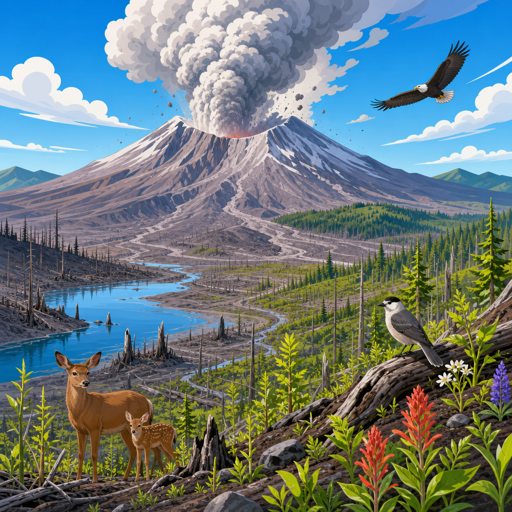
The 1980 eruption was environmentally unique because the mountain did not simply erupt vertically. A bulging north flank collapsed, producing a massive debris avalanche that removed the summit and reduced the mountain’s height by about 400 meters. The lateral blast that followed flattened or scorched forests across approximately 600 square kilometers. Pyroclastic flows then buried valleys with superheated material, while lahars, or volcanic mudflows, surged through drainage systems including the Toutle and Cowlitz Rivers. This combination of landslide, blast, ashfall, and sediment-charged flooding created a layered disturbance rarely observed with such scientific detail.
Three impact zones emerged. The blowdown zone lost standing timber almost instantly. The scorch zone experienced intense heat but retained more biological refuges. The outer ashfall zone suffered less visible damage but still faced disrupted agriculture, water contamination, and transport problems. These zones became critical for studying how severity shapes recovery. In plain terms, Mount St. Helens proved that the force, direction, and material of an eruption matter as much as the eruption itself when predicting long-term environmental outcomes.
Forest recovery, ecological succession, and the power of biological legacies
One of the most important long-term findings from Mount St. Helens is that ecosystems rarely restart from zero. Early public images suggested a moonscape, but buried root systems, surviving seeds, snow-protected plants, pocket gophers, amphibians, insects, and logs all acted as biological legacies. These remnants accelerated recovery in places where conditions looked hopeless. Lupines became a classic example. They colonized pumice plains, fixed nitrogen, trapped organic matter, and created microhabitats for other species. Over time, they helped improve poor volcanic substrates that initially lacked the nutrients and structure needed for broader plant establishment.
Forest recovery varied sharply by elevation, slope, burial depth, and salvage logging history. In unmanaged areas, fallen trees retained moisture, reduced erosion, and provided habitat for beetles, fungi, birds, and small mammals. In salvaged areas, some timber removal reduced fuel and facilitated replanting, but it also stripped away habitat complexity. This debate still shapes restoration after global disasters. Managers in volcanic regions now ask whether cleanup should prioritize commercial recovery, erosion control, or ecological function. Mount St. Helens showed that dead wood is not simply waste. It is often infrastructure for recovery.
Rivers, sediment, and water quality decades after the blast
The most persistent environmental impact was not ash in the sky but sediment in the watershed. The debris avalanche filled the North Fork Toutle River valley with enormous volumes of unstable material. Rain and snowmelt then reworked that sediment for years, raising riverbeds, increasing flood risk, and threatening navigation infrastructure downstream. The U.S. Army Corps of Engineers eventually built the Sediment Retention Structure to reduce sediment delivery. Even with engineering controls, downstream channels, floodplains, and aquatic habitats remained shaped by the eruption for decades.
Water quality effects changed over time. Immediately after the eruption, many lakes and streams experienced low oxygen, high acidity in some areas, elevated nutrients, and large loads of suspended solids. Fish kills occurred, and aquatic food webs were disrupted. Over the longer term, some systems recovered faster than expected as nutrients cycled and vegetation stabilized banks. Others remained vulnerable because fine sediment embedded stream gravels, affecting spawning habitat for salmonids. This distinction matters worldwide. After a volcanic event, the most visible destruction may pass quickly, while river impairment continues through repeated storms, channel migration, and sediment pulses long after the crater stops erupting.
| Environmental component | Immediate impact after 1980 eruption | Long-term effect observed | Global lesson for disaster management |
|---|---|---|---|
| Forest ecosystems | Blowdown, scorching, burial, massive tree mortality | Uneven regrowth shaped by survivors, logs, soils, and management choices | Protect remnant habitat and avoid assuming total ecological reset |
| River systems | Valleys filled, channels rerouted, lahars increased flooding | Decades of sediment transport, aggradation, and habitat alteration | Monitor watersheds long after the eruption, not just eruption zones |
| Wildlife | Large mammal and bird losses in blast area | Species returned in stages, depending on refuges and food-web recovery | Recovery depends on landscape connectivity and micro-survivors |
| Soils and substrates | Ash and pumice deposits, nutrient imbalance, poor structure | Gradual soil formation aided by pioneer plants and decomposition | Early colonizers can determine decades of ecosystem trajectory |
| Human management | Emergency closures, dredging, hazard response | New monument model, sediment engineering, adaptive research programs | Blend protection, infrastructure planning, and long-term science |
Wildlife responses: loss, adaptation, and return
Wildlife impacts were severe but highly uneven. Elk, black-tailed deer, bears, birds, and countless smaller organisms died in the blast zone, yet not all populations collapsed regionally. Some species persisted in sheltered pockets under snow or behind terrain barriers. Amphibians survived in wet refuges. Burrowing mammals such as pocket gophers influenced early soil recovery by mixing organic matter and improving seedbed conditions. Aquatic insects recolonized from upstream reaches or surviving ponds, supporting gradual fish and bird return.
Over decades, wildlife patterns reflected habitat structure rather than simple time since eruption. Open-country species benefited early from sparse vegetation. Later, as shrubs and young trees expanded, different birds and mammals returned. Elk populations became especially visible in some recovering areas, sometimes browsing heavily enough to slow woody plant establishment. That dynamic is important because recovery is not always a smooth march toward pre-eruption conditions. Disturbance can create a new ecosystem trajectory. Similar patterns have been observed after eruptions at Pinatubo and Chaitén, where sediment, vegetation structure, and human land use shaped animal return more than the eruption date alone.
Soils, lakes, and new habitats created by catastrophe
Volcanic disasters destroy habitat, but they also create it. Mount St. Helens formed new ponds, wetlands, debris fields, and the horseshoe-shaped crater that still governs drainage and geomorphic processes. Spirit Lake is the best-known example. The eruption displaced the lake with a giant wave, filled it with floating logs and debris, and drastically altered its chemistry and ecology. Many observers assumed it would remain biologically dead for generations. Instead, microbial processes, nutrient cycling, and recolonization changed the system faster than expected, though not in a straight line. Spirit Lake became a reminder that lake recovery after disaster can be dynamic, messy, and surprisingly productive.
Soil formation also challenged simplistic assumptions. Fresh tephra and pumice are not mature soil. They can be drought-prone, unstable, and poor in available nitrogen. But once pioneer plants establish, litter accumulates, microbes expand, and weathering begins to build more functional soil horizons. In the field, this means environmental recovery can depend on modest-looking processes: a nitrogen-fixing plant, a retained log, an undisturbed moss patch, or a surviving insect community. These small components often decide whether a blasted surface remains barren or becomes the foundation for a recovering ecosystem.
Human intervention versus natural recovery
Mount St. Helens became a defining case in the debate over intervention. Some areas were replanted, roaded, logged, or engineered for flood control. Other areas were intentionally left alone for research. This contrast was invaluable. Scientists could compare natural succession with managed restoration on similar terrain. Results showed that intervention can be useful when protecting communities, stabilizing infrastructure, or reducing immediate hazards. However, intensive cleanup can also erase structural complexity that ecosystems need. Salvage logging, for example, can remove standing snags and downed wood that support nutrient cycling and wildlife shelter.
The broader lesson is not that intervention is wrong. It is that goals must be explicit. If the objective is timber production, one strategy follows. If the objective is biodiversity recovery, another follows. If the objective is downstream flood protection, engineering may dominate. Mount St. Helens forced agencies to separate these aims instead of pretending one action serves all of them equally. That is now standard thinking in post-disaster landscape management from New Zealand volcanoes to lahar-prone slopes near densely populated Andean valleys.
Global case studies: what Mount St. Helens teaches the world
As a hub article for global case studies in environmental disasters, Mount St. Helens is especially valuable because it is both unique and transferable. Mount Pinatubo in the Philippines, which erupted in 1991, produced major global climate effects through sulfur dioxide emissions and caused years of lahar hazards as monsoon rains remobilized ash and volcanic debris. The similarity lies in the long tail of watershed disruption. Communities often suffer more from recurring sediment-charged floods after the eruption than from the eruption day itself.
Eyjafjallajökull in Iceland in 2010 demonstrated a different lesson: a moderate eruption can have outsized international consequences when ash interacts with aviation systems. Chaitén in Chile in 2008 highlighted how ash burial and river changes can transform towns and forests. Japan’s Unzen and Indonesia’s Merapi show the importance of exclusion zones, dome-collapse monitoring, and lahar channels where people live close to active slopes. Mount St. Helens helps interpret all of these examples because it established a benchmark for long-term ecological monitoring, hazard zoning, and the study of natural recovery in a protected scientific landscape.
Another global lesson is institutional. The U.S. Geological Survey’s Volcano Hazards Program, coordinated mapping, and long-duration monitoring illustrate that disaster science must be continuous. Volcanic risk is not managed by one evacuation order. It requires seismic networks, gas measurements, deformation monitoring, sediment accounting, land-use controls, and communication that remains credible after the emergency phase. Countries that invest in this continuity reduce both environmental damage and human loss.
Policy, climate context, and why this eruption still matters
Mount St. Helens still matters because it changed how agencies think about cascading environmental disasters. A volcanic eruption can trigger landslides, floodplain aggradation, fisheries decline, transportation shutdowns, forest policy disputes, and long-term restoration costs at once. In today’s climate context, heavier rainfall in some regions can worsen post-eruption erosion and lahar risk. Warmer temperatures can shift snowpack and runoff timing, which affects sediment delivery and habitat recovery. Those interactions make historical case studies more useful, not less.
For planners, the central takeaway is practical. Protect monitoring budgets, preserve refugia where possible, manage watersheds beyond the crater, and recognize that recovery is spatially uneven. For educators and researchers, Mount St. Helens remains one of the best documented environmental disaster case studies on Earth. For readers exploring global case studies, it is the hub because it connects geology, ecology, hydrology, public policy, and long-term resilience in one place.
The long-term environmental impact of the Mount St. Helens eruption was profound, but it was not defined by permanent ruin. The eruption destroyed forests, buried valleys, damaged rivers, and killed wildlife, yet it also revealed how landscapes reorganize through succession, sediment movement, habitat creation, and adaptive management. Its greatest lesson is that environmental disasters unfold over decades. Immediate damage assessments capture only the opening chapter.
Mount St. Helens remains essential to understanding global case studies because it offers hard evidence on what lasts: altered watersheds, changing soils, shifting wildlife communities, and management choices that influence recovery. It also proves that natural systems can rebound in unexpected ways when remnant life and ecological processes are allowed to work. If you are building a deeper understanding of environmental disasters, use Mount St. Helens as your starting point, then compare its lessons with Pinatubo, Merapi, Iceland, and other major eruption landscapes.
Frequently Asked Questions
How did the 1980 Mount St. Helens eruption change the surrounding landscape over the long term?
The 1980 Mount St. Helens eruption transformed the landscape on a scale that was both immediate and long-lasting. The blast began after a magnitude 5.1 earthquake triggered a massive landslide, which removed the volcano’s northern flank and released a powerful lateral explosion. In minutes, forests were flattened, slopes were stripped bare, valleys were buried, and Spirit Lake was dramatically altered by millions of fallen trees and displaced sediment. Entire drainage systems were rerouted, and huge deposits of ash, rock, and volcanic debris reshaped the topography of the region.
Over the long term, the eruption continued to influence the land through erosion, sediment transport, and slow ecological rebuilding. Rivers such as the Toutle became choked with sediment, raising riverbeds and increasing flood risk far downstream. Debris avalanches and lahars filled channels and floodplains, leaving unstable deposits that persisted for decades. At the same time, the volcano created a rare natural laboratory where scientists could observe how fresh landscapes develop after catastrophic disturbance. New ponds, stream channels, and plant communities formed over time, showing that volcanic destruction does not simply erase an ecosystem; it resets it and redirects its future development in ways that can last generations.
What were the long-term effects of the eruption on forests and plant life?
The eruption had profoundly uneven effects on forests, which is one reason it became so important to environmental science. Some areas close to the blast were completely annihilated, with trees snapped, scorched, or blown down over vast distances. Other places, depending on topography, wind direction, snow cover, and distance from the volcano, experienced partial damage or were surprisingly protected. This mosaic of destruction and survival gave researchers an unusually detailed view of how forests respond to extreme disturbance.
In the decades that followed, plant recovery did not happen in a simple, uniform way. Rather than beginning from an entirely lifeless surface, recovery often depended on “biological legacies” such as buried seeds, root systems, surviving patches of vegetation, and nutrient inputs from nearby less-damaged zones. Species such as lupines played an especially important role because they helped stabilize soils and enrich them with nitrogen, making it easier for other plants to establish. Over time, meadows, shrubs, and young forests reappeared, but the composition of these communities often differed from what existed before 1980.
The long-term lesson is that forest recovery after volcanic eruption is shaped by both destruction and survival. Mount St. Helens showed that even in blast zones, ecological renewal can begin sooner than expected, but it may follow a different trajectory than the original forest. That insight has influenced modern restoration ecology, especially in understanding how disturbed landscapes recover through natural processes rather than only through human replanting.
How did the eruption affect rivers, lakes, and water quality for years afterward?
One of the most enduring environmental effects of the Mount St. Helens eruption was its impact on waterways. The eruption sent enormous quantities of ash, mud, trees, and volcanic sediment into rivers and lakes, drastically altering water flow and quality. Spirit Lake was one of the most visible examples: it was lifted by the force of the debris avalanche, filled with floating timber, and chemically altered by decomposing organic material and volcanic inputs. Nearby streams and river systems also experienced sharp increases in sediment loads, turbidity, and channel instability.
These effects did not disappear once the ash settled. Sediment from the eruption continued moving through the watershed for decades, affecting fisheries, navigation, flood control, and habitat quality. River channels widened, aggraded, and shifted, forcing expensive engineering and management responses. Elevated sediment loads damaged spawning grounds and changed aquatic ecosystems by burying gravel beds and altering stream temperatures and oxygen conditions. In some places, water chemistry gradually improved, but physical instability in channels persisted much longer.
The eruption became a defining case study in how volcanic events can reshape watersheds far beyond the immediate blast zone. It also highlighted the close connection between upland disturbance and downstream consequences. For environmental planners and hydrologists, Mount St. Helens remains an important reminder that the long-term environmental footprint of a volcanic eruption often travels through rivers, affecting communities, habitats, and infrastructure many miles away from the volcano itself.
What happened to wildlife after the eruption, and how did animal populations recover?
Wildlife response to the eruption was complex, and recovery varied widely by species and habitat. Many animals in the direct blast zone were killed, especially large mammals, birds, and species unable to escape the heat, shock wave, or debris. Aquatic life also suffered heavily in streams and lakes impacted by ash, sediment, and low oxygen conditions. Yet not all wildlife disappeared. Some animals survived in protected microhabitats, underground burrows, beneath snowpacks, or in less severely damaged pockets of the landscape.
In the years after the eruption, certain species returned more quickly than scientists initially expected. Insects, amphibians, small mammals, and scavengers often played early roles in reestablishing food webs. Elk became particularly notable in the recovering landscape, although their growing numbers also influenced vegetation patterns by browsing heavily on young plants. Birds recolonized as habitat structure returned, and aquatic species slowly recovered where stream conditions stabilized. The process was uneven, however, because newly formed habitats did not always match pre-eruption ecosystems.
The long-term ecological importance of Mount St. Helens lies in demonstrating that wildlife recovery depends not just on survival, but on habitat change, food availability, landscape connectivity, and competition among species. The eruption helped scientists understand succession as an animal story as much as a plant story. It showed that after a major disaster, ecosystems do not simply “bounce back” to their former state; instead, wildlife communities reorganize over time, often creating a new ecological balance shaped by the disturbance itself.
Why is Mount St. Helens still important for climate science, hazard planning, and disaster policy?
Mount St. Helens remains highly important because it provided a modern, intensely studied example of how one volcanic eruption can produce environmental consequences that extend far beyond the moment of explosion. From a climate perspective, the eruption released ash and gases into the atmosphere, though its global climatic effect was modest compared with much larger eruptions such as Pinatubo. Even so, it helped improve scientific understanding of how volcanic emissions interact with atmospheric processes, visibility, air quality, and regional environmental conditions. It also reinforced the idea that the climate effects of eruptions depend heavily on eruption size, altitude of emissions, and sulfur content.
Its greatest long-term significance may be in hazard planning and disaster policy. The eruption highlighted the danger of lateral blasts, debris avalanches, lahars, and secondary impacts such as sediment-choked rivers and downstream flooding. It showed that volcanic risk is not limited to lava flows near a summit; it can involve wide-area devastation, infrastructure loss, public health concerns from ashfall, and long-term watershed management challenges. These lessons have informed volcano monitoring, evacuation planning, hazard mapping, and interagency coordination in the United States and around the world.
Just as important, Mount St. Helens changed how scientists and policymakers think about recovery. The eruption demonstrated that environmental disasters should be evaluated over decades, not just days or months. Forest succession, river adjustment, wildlife return, and sediment management all unfolded over long time scales. Because of this, Mount St. Helens is still used as a benchmark case in environmental disasters research, offering a rare and authoritative record of how a single eruption can alter landscapes, ecosystems, and public policy for generations.